Companies
Santa Cruz County Sheriff’s office releases stunning drone imagery of CZU fire damage


(Contributed)
Teams flew over 315 flights in the two days collecting photos, panoramas, and video
- 360 Panorama Map: https://arcg.is/05GDab
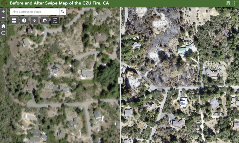
- Before/After Swipe Map: https://arcg.is/1OWbb5
- Youtube Video Tutorial (watch to learn how to use interactive map):
From September 24-25, 2020, up to 15 drone teams were deployed at the request of Santa Cruz Co. Sheriff’s Office and under the coordination of Alameda County Sheriff’s Office. Teams included Country Costa County Sherrif’s Office, Stockton Police, and Santa Cruz County Sheriff’s Office. GeoAcuity consulted on all technical data support. Teams flew over 315 flights in the two days collecting photos, panoramas, and video using the CAL FIRE damage assessment map for reference.
From YouTube:
GeoAcuity is a detail-oriented, veteran-owned, geospatial consultancy with significant technical and project management expertise to address complex job requirements. One of our offerings is as emergency geospatial consultants for public agencies for deploying rapid UAV data assessments. We supported an interagency task force of drone teams in the aftermath of the CZU Complex Fire in Santa Cruz County CA in Sept. of 2020. Here we offer a tutorial on the final map layer deliverables. GeoAcuity assists this teams in the processing, visualization of image layers, and building of public web application. We work alongside public agency drone teams to get their data out as fast as possible to whoever needs it. We are a California-based company but available for contracting, training, and consulting opportunities across the globe. Reach out to contact@geoacuity.com for more information. This work was done as a contractor under the Alameda County Sheriff’s on behalf of the Santa Cruz County Sheriff’s office request for aerial drone data.
###